A number of locations in the Northwest had their first frost this morning or yesterday morning. Frost season is here.
Below are the low temperatures today for all locations that dropped to 33F or below. Keep in mind these temperatures are for the standard height of 2 meters (roughly 6 ft) above the ground. During the cool season, temperatures often get colder towards the surface.
Several locations in western Washington dropped in the upper 20s, as did observing locations over the Columbia Basin. But if you want real cold, Montana should be your destination; some temperatures bottomed out below 0F!

You will notice that Northwest Washington was particularly cold this morning. Want to know why?
Because the skies cleared overnight in that area, allowing the surface to effectively emit infrared radiation to space (see visible satellite image this morning).

So what does the next week look like? Before I show you the predicted temperatures, let me remind you that surface temperatures (where frost is found!) can be several degrees below reported or forecast surface air temperatures, which are valid at 2-meter above the surface.
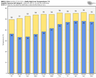
For SeaTac, temperatures are predicted to drop around 33F on Saturday morning. Frost is possible at the Airport!

Eastern Washington? In Yakima there will be a hard freeze with temperatures getting down to the low twenties on several days.

As noted before, the low temperatures depend on distance to water, urbanization, and elevation, with valleys being colder. To illustrate this pattern, below is a very high-resolution prediction of the 2-meter temperatures on Saturday morning at 8 AM from the high-resolution UW modeling system for western Washington.

Below-freezing temperatures are indicated by the blush and purple colors. Warmer near the water and cooler in river valleys. Very cold in the Cascades.
You might ask whether this frosty period in late October is unusual.
For SeaTac Airport, the average day of the first freeze is November 14, so if we do get some frost at the airport during the next few days, it will be about two weeks early. In contrast, for Olympia, the average first frost date is October 6 so freezing temperatures are late there.
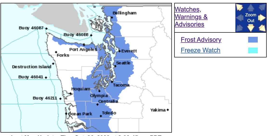
Finally, let me note that the National Weather Service has both a frost advisory and a freeze watch out.


I hope we get a good snow storm out two this winter.
ReplyDeleteWell, we are certainly ahead of last year...!
ReplyDeleteI've see frost as early as September near Hood Canal.
ReplyDeleteYes, it's been really cold up here near Mt Baker. Last night's low was 23.2 F because it was so clear, and the 24 hr high was only 41.9 F. I'm often mystified by some folks' belief that last winter's mountain snowfall was irregularly low when the situation was pretty normal for the Mt Baker Ski Area (617 inches last season). Their snowfall statistics are at this URL
ReplyDeletehttps://www.mtbaker.us/the-mountain/snowfall-statistics/
...and there have already been a few snow-dumps Sept-October. I haven't driven "up to the top" but I followed a camper down the highway yesterday that had about 8-10" of snow on its roof. Just sharing what I'm seeing (direct observation) up here.
GlacierBake, the people who believe that last winter's mountain snowfall was irregularly low are the same individuals who think that the world will end in a few years unless we agree to be taxed to infinity in order to impoverish ourselves to their Climate Gods.
DeleteEric: So it seems. The long term record indicates (no, "reflects") a wide range of variability over time - that's the reality. The ecosystem didn't crash and the streams didn't stop flowing as a result of there only being 277 inches of snow over the 1980-81 snow season at Mt Baker. Similarly, the "world record" 1134 inch snow season 1998-99 didn't cause flood disasters nor did it signal the start of an ice age. For all the observations, "the tea leaves" (statistics) read "wide seasonal variability" with plenty of surprises. We do have "frost on the pumpkin" some Halloweens - I recall kids trick-or-treating in snowsuits. "Early cold" may foretell a rainy (not snowy) winter or it may not. We'll see! I do think it's tragic (worse than tragic: "wrong") that so much about weather is misunderstood and over-reacted to.
DeleteThis seems like an odd el nino event. Are we actually in la Nina?
ReplyDeleteCurious Cliff.
This morning the NOAA website showed a low of 19 degrees at the Olympia Regional airport. On October 25, however, at 1:35pm the temperature reported was 70 degrees then at 1:40pm it showed 32 degrees so not sure you can trust the 19 degrees temperature. (That day the reported temperatures were really wonky.) Meanwhile this morning in Olympia, east of downtown, we had a low of 27 degrees.
ReplyDeleteWe had frost Friday morning. 32F and clear. Once it warmed enough to melt the frost, we had 36F and dense fog. The fog burned off for a nice sunny day.
ReplyDeleteWe live about a mile north of Snoqualmie Falls. There's a ridge about a 1/2 mile north of us. I often see low clouds obscuring the ridge.