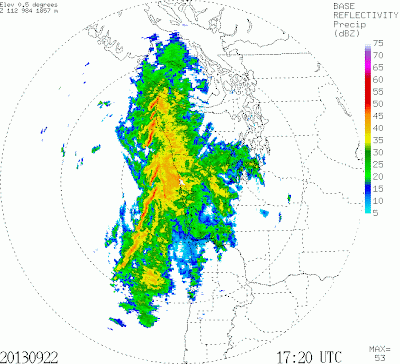
During the 1970s, work by Professor Peter Hobbs and colleagues (at the UW!) explored offshore fronts with aircraft and coastal (research) radars. They found that many fronts, and particularly the strong ones, were not unbroken lines of precipitation, temperature change, and wind shift; rather, the fronts were often corrugated, with areas of heavy precipitation (and large changes in temperature and wind) separated by gap areas, where changes were much more gradual. Sunday's front had these characteristics: let me show you.
Here are two radar images at 9:20 and 10:20 AM on Sunday morning. The front is offshore and heaviest precipitation with the front is denoted by red. Can you see the corrugation and the core/gap areas?
Here is a blow up at 10:08 AM of a core/gap combo:
Pretty neat. Aircraft penetrations have showed radical difference in the frontal characteristics in these two areas. A true story I love to tell:During the 90s we have field experiment called COAST in which we flew the NOAA P3 Hurricane Hunter aircraft into a Pacific front. The scientists wanted to go out and cross one of the cores to see what it was like. The NOAA P3 pilots agreed...they had been through many hurricanes, so they were not concerned. Well, the passage through the core at around 2000 ft was very, very intense--with several g's up and down and the coffee pot broke off in the rear of the aircraft and life rafts pulled out from under the seats. Several scientists thought they were going to die. The pilots were shaken...no more flights through cores at low levels--this was a lot worse than going through hurricane eye walls. The return was at 5,000 ft through a gap...no problem.
Why the cores and gaps? It is thought to be due to some kind of wavelike instability forced by the large wind shears along strong fronts.
To get an idea how strong Sunday's front was, here is a graph of sustained winds, gusts, and pressure at Destruction Island, just off the central Washington coast. Time increases to the right. Look in the middle of the graph for the right time. Wind gusts him 45 knots, around 52 mph. The pressure shows a very sharp dip...the lowest pressures are associated with the front.
Reading the Northwest Sky
I am giving a five-lecture evening short course: "Reading the Northwest Sky: Understanding Our Weather and Climate"
October 1, October 22, November 5, November 26, December 3
Kane Hall: University of Washington
Co-Presented by University of Washington Alumni Association and Seattle Public Lectures.
If anyone is interested, more information here.


It kinda looks like the threading on a very long screw. Like the clouds may be rotating horizontally or rolling over themselves as they move.
ReplyDeleteCliff's story about crashing through the front reminds me of Jeff Masters' description of being hammered by a hurricane, threatened by flying soda cans. C-130: what a great aircraft! No coffee pot can stand up to the same punishment.
ReplyDeleteCliff, according to NWS we're likely to get a bunch of precipitation this weekend. What's the backstory on that? Should we tune up our sump pumps?
"The NOAA P3 pilots agreed...they had been through many hurricanes... Well, the passage through the core at around 2000 ft was very, very intense--with several g's up and down and the coffee pot broke off in the rear of the aircraft and life rafts pulled out from under the seats."
ReplyDeleteYes, we went in low... At night... the only thing we could see in that blackness was the St Elmos sparking blue across the windscreen, and an occasional flash of far off lightning. I was in the right seat, Cdr Phil Kennedy was in the left. The G-meter sits in front of the copilot. The nose radar showed a sharp gradient from nothing to the Red Stuff (with a few flecks of purple). Phil & I knew it was going to be rough, so we had everyone tighten belts & lock harnesses.... then, Whamm! You hit it and take your beating... the G-meter went instantly to +5, then to -2Gs. Negative Gs are very bad, that front was trying to push us into the water....so go to full power, climb back up and push on through... those bands were narrow, so we were back to normal in a couple of wrestling minutes. Now check for damage, the crew reports only minor stuff, a coffee pot, a loose life raft and a few things tossed around, nothing we hadn't seen before. Our guests(scientists) weren't that happy, especially the new ones, they'd never been roughed up like that... But our old pros (like Brad Smull, Robert Houze and of course you Cliff) weren't fazed, you'd seen all this stuff before flying with us on other projects. And the P-3 Orion, what a great aircraft, lots of power and a tough, strong airframe; it could take the beating when us on the inside could not... So it's time to turn around and head back in on the next pass, maybe we'll pick a little softer spot in the convection, just to let the newbies get their stomachs back on line... and ten hours later you land back in Seattle, another COAST flight complete.
Yes, we'd fly into the red stuff (on the radar) just about everywhere - except one place - Tornado Alley - you will come out in little pieces if you tried that stunt there...