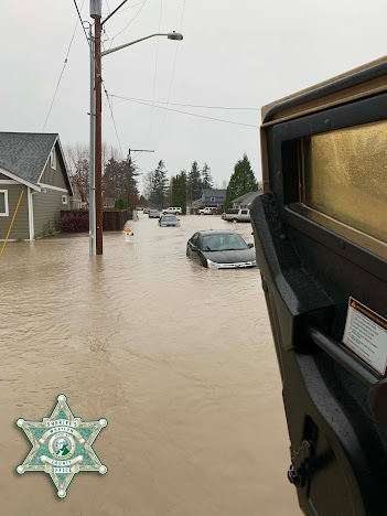
Extreme flooding forced by extraordinary precipitation has flooded the town of Sumas and other locales in Whatcom County.
Landslides closed I5 and some other roads, and sewage overflows are threatening some water supplies in the area.
The pictures are stunning.
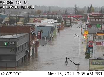
Downtown Sumas was flooded this morning.
The nearby town of Everson is flooded.
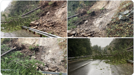
And landslides closed I5 near Bellingham:
The Nooksack River achieved its all-time record river stage.
The cause of these terrible conditions is very wet autumn followed by extremely heavy rainfall over the weekend. Let me show you.
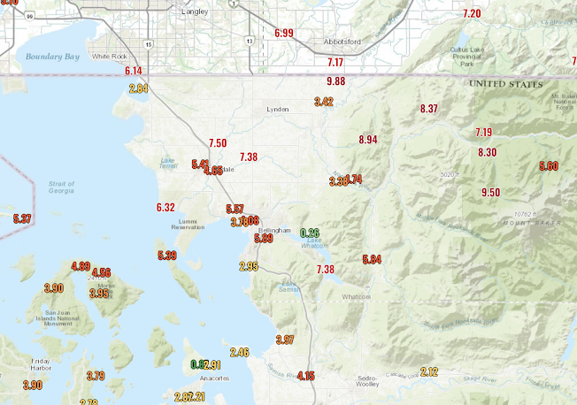
Here are the 72 hr totals ending at 6 PM today. A number of locations reported 8-10 inches...unbelievable... with 8.94 inches as Sumas Mountain and 9.88 inches near the international border. Orcas Island, which is closer to the Olympic Rainshadow, got around 5 inches.
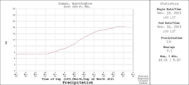
But what made this even so deadly is that most of the precipitation fell in a 24-h period on Sunday (midnight to midnight). This is shown below for the Sumas Mountain observing site. Around 7 inches in 24 hours. Wow.
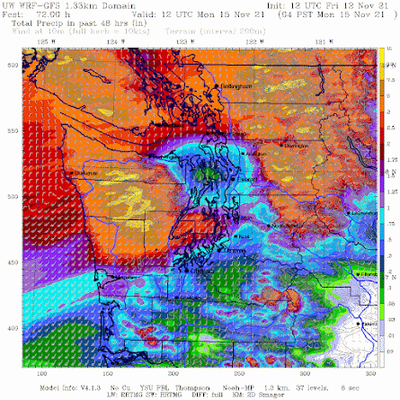
I am happy to report that weather forecast models accurately predicted this torrential rain, something shown by the forecast of accumulated rain made on Friday at 4 AM for the total through 4 AM Monday. Not bad. Pretty impressive rainshadow to the NE of the Olympics.
You see the yellow colors....those are the heaviest amounts.
We are going to dry out during the next several days, but the damage has been done.
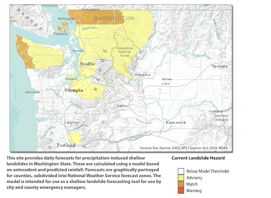
We are now "enjoying" the wettest autumn on record for many locations in western Washington...but that "honor" should be lost with the dry period ahead. But the ground is saturated throughout the region, and the WA State DNR's landslide warning system has areas of concern, particularly Whatcom County and along the coast (the other area with lots of rain).
Winds
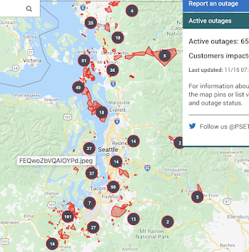
And yes, we had strong winds today with the intense front, with gusts reaching 50-65 miles per hour in places. Whidbey Island is essentially blacked out, with large outages in the South Sound and elsewhere (see below)
We knew all this was coming..... the big question is how society can learn to use the increasing weather forecasting prowess to protect life and property.
I have said this many times, but it bears repeating: the first line of defense against extreme weather is excellent weather prediction, which should allow us to prevent most loss of life and injury and reduce economic damage.
Deaths from extreme weather are plummeting around the world and better forecasting is one of the reasons. You would not know that from what you read in the Seattle Times and many other media sources, which play up extreme weather as an apocalyptic threat to the existence of humanity.
Announcement:
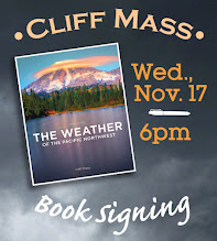
I will be doing a book signing and dinner event at Ivar's Salmon House in Seattle on Wednesday, November 17th (6 PM). You can come just to purchase a book and get it personalized or you can stay for a special dinner, where I will be giving a weather talk. More information on the event is found here. You need to make reservations for the dinner (only 80 spaces available). And information about the new edition of my book is here.
Only about 10 spots are left, so if you want to go, reserve a place soon.



In the hills NW of Longview we had 8.1" in the past seven days. Not the disaster that Whatcom and Skagit counties are dealing with, but the #3 wettest day in my 64+ years on the planet, and the wettest 7-day span I've experienced.
ReplyDeleteWe're now above the November PRISM normal, on day fifteen. Ugh.
Cliff, Coupeville on Whidbey Island reached a gust of 75mph, and West Beach, also on Whidbey,reached a gust of 84mph!
ReplyDeleteThat Friday forecast was impressive. The Olympic rain shadow is shifty. Orcas was definitely not in the shadow for this event. The road at Doe Bay on Orcas was washed out.
ReplyDeleteDan....my point was that EVEN in the rainshadow of the Olympics, northern Orcas still got a lot of rain..cliff
DeleteAgree! Did not mean it as a criticism. I live near the edge of the rain shadow so sometimes we are in and sometimes we are out. For this event we were out of the shadow (lots of rain), but could see the bright sky just to the south throughout most of the 'event'.
DeleteThe rain shadow was very impressive, with a dramatic shift in 72 hour precipitation north versus south of the Stillaguamish.
DeleteOur barometer in NE Seattle bottomed out at 996 millibars yesterday for an hour after noon and this morning is hot to 1024. That’s an impressive turnaround. Our rainfall wasn’t abnormal. We’ve had just under two inches in 48 hours, testimony to the forecast prediction of heaviest rainfall on the coast and north of us.
ReplyDeleteAnd of course the difference in temperatures from yesterday to today is as the forecast promised; 59F yesterday morning at our home in NE Seattle and 41F this morning. Big difference.
ReplyDeleteBC also got hammered with some suburbs of Vancouver being underwater, and motorists stranded on highways because of mudslides. Much ofthe province is under emergency status at present, scary.
ReplyDeleteOh my - I'm stunned to see how people misinterpret "range of normal". I've been watching weather for almost 50 years here in the Nooksack basin headwaters (Glacier WA), and this event effectively represents the high end of variation. I say this knowing what weather reality is, day-to-day - sheer observation. Weather here varies, people. I posted footage of our local Nooksack Falls with the river running at 14,300 cfs (awesome) but transitory. I've been seeing tweets to my vid about 'climate apocalypse' that are nothing short of nihilist claptrap IMHO.
ReplyDeleteJust as quickly as the waters rise, they plummet. We had 8.94" precip over three days, but that is not - I repeat not - unheard of. The more that people learn about the incredible variability of weather (nature) the better, the less panicky they should be. (Love the new edition of your book, Prof.) I'm afraid the headlines don't teach, 'just drum-up distorted fear porn.
Local and National media also, year-over-year, ignore the science of the NW relative to the rest of the nation and profit from misrepresenting “flooding” in the NW. There’s no doubt we have “flooding” and no doubt that it can be damaging. But the geology of the NW has created shorter steeper rivers, rocky mountains with thin soils that generate quick runoff, and relatively smaller flood plains. The water creates flooding, but has for all of the human history here, and owing to the topography the water runoff climbs quickly and declines quickly. We’re not the Midwest where flooding can last for weeks, and even months. Snoqualmie Falls gets featured nearly annually at 30,000+ CFS, and last week hit 45,000. But that’s not “abnormal.” Out of ordinary is a crest I saw decades ago in 1990 at over 70,000 CFS, and that statistically isn’t likely again for awhile. The media needs to sell advertising and flood waters are a draw for viewers.
DeleteYes! These campaigns to demoralize us need to end. If we were ALLOWED to be prosperous we could probably withstand an alien invasion or a meteorite collision. For the weather, we could sit back, take a day or two off, and enjoy nature showing off.
DeleteGB - you know that anything will trigger the predictions of oncoming doom. They have an agenda to push in order to keep the rest of the plebes in lockdown...forever.
ReplyDeletePretty messy up here in Canada with the Nooksack flooding into the Sumas and effectively recreating the lake that existed here a hundred years ago. I’m guessing that this helps the Nooksack avoid flooding. All routes to the rest of Canada are now cutoff.
ReplyDeleteHey Cliff - the Nooksack is creating a catastrophe north of the border by flooding Sumas Prairie - essentially the old Sumas Lakebed, drained in the early 1920s.
ReplyDeletehttps://www.theprogress.com/news/its-not-over-for-abbotsford-officials-brief-public-as-flood-water-pours-into-sumas-prairie/
Years ago gravel companies scraped sandbars on the Nooksack and there was less upriver flooding. That worked pretty well. Still flooded of course but more commonly downriver Ferndale to the mouth at Marietta.
DeleteClimate change, anyone?
ReplyDeleteNormal weather patterns, anyone?
DeleteGee, I thought your crowd's mantra was that the weather isn't climate. Or was it more like "We will say anything to push our agenda, no matter how much we contradict ourselves?" LOL
DeleteI wouldn't be surprised if the cost of road and rail repair for the routes connecting Vancouver/Lower Mainland to the Interior of BC will cost billions. The Coquihalla was a new superhighway designed and built only a few decades ago to be resilient against the 1 in 200 or the 1 in 500 year flood events (from memory, I had friends working on design and environmental impact assessment). I hope Cliff you will post some of the images of the Trans Canada Highway 401 deeply submerged, only overpasses above water, and one of the Coquihalla where several hundred metres of bridge and approaches were washed out. The entire province has just issued a State of Emergency for the whole province to guarantee food and essential goods. Luckily the routes to the US are mostly intact as otherwise food shortages would be real. As it is we already have panic buying going on. For us, this wasn't the once in a decade or two event.
ReplyDeleteIts even much worse than I wrote yesterday. News conferences last night and this morning show this storm will cause a major hit to not only the BC economy, but the entire Canadian one. Never before has every single road, highway, and rail connection from Vancouver to the rest of the country been cut. Bridges down, slides and washouts spread out over hundreds of kilometres radius. Some of the smaller highways are going to be going to at least single lane essential traffic soon, but we haven't hear how long the main highways or rail is going to be out, and this effectively shuts down much of the entire Canadian economy. Grain, oil, lumber, manufactured goods and natural gas can't be exported to the rest of the world through the Pacific except through Prince Rupert next to the Alaska border, and that route was near capacity before the storm. Its a boon to the Washington and California economy as all the trucks are now going through US highways around the blockages and I'm sure a lot of container traffic will head south, but this will only hurt efforts to get supply chains working properly in the US. The scale of the economic hit to Canada is enormous.
ReplyDeleteThe flooding in the Fraser Valley in 1948 and 1896 was much greater, but the weather behind that historic flooding was entirely different. In those years, especially deep snowpacks melted especially rapidly in a late hot spring. This latest one was completely different happening in the fall and was almost entirely due to rain from the atmospheric river.
Thank you for hosting the dinner, Cliff! It was great to see other blog readers in person.
ReplyDeleteWith the sumas prairie flooding blocking Canada's Highway 1, I'm wondering how long before the water recedes, and if the rain in the long-term forecast will prolong the flood or make it worse. Is it substantial amounts?
ReplyDelete