A well-timed cooler/wetter period is now ahead, which should reduce the potential for local wildfires next week.
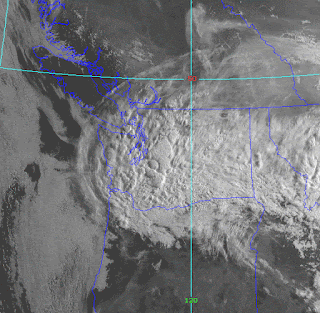
This morning, a band of clouds with embedded cumulus convection extends from Idaho to across the entire State of Washington.
The latest weather radar image shows some rain in this cloud mass, particularly over the southern Cascades and into southwest Washington.
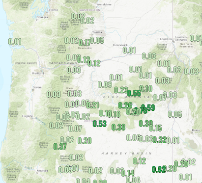
This could band, associated with a weak atmospheric low-pressure area, was over eastern Oregon and southeast Washington yesterday, resulting in significant rain, particularly over the high plateau of eastern Oregon.
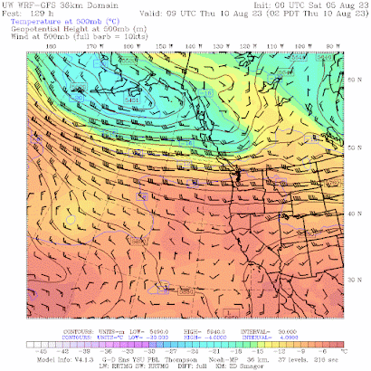
The main rain event will occur on Wednesday and Thursday as a relatively deep low over the Gulf of Alaska extends into BC, producing an unusually strong westerly jet stream coming right into the Northwest (see below). A fall-like pattern.
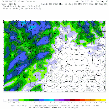
This pattern will bring rain in western Washington and Oregon on Wednesday, with some locations getting as much as half an inch (see below). BC will get wet as well.
The latest forecast for Seattle from weather.com (a very good source by the way), has moderate temperatures next week (see below).


NW of KELN Ellensburg, we got a sprinkle during the night. The temperature drop is nice
ReplyDelete: 80s rather than 90s. Hope the longer term forecast is wrong.
After enduring 74 summers in the PNW, this one has to be near the top. Outstanding weather this summer.
ReplyDeleteFive days ago the forecast was for sunny and warm this weekend. What was missed then.
ReplyDeleteHere is the forecast on Thursday from the NWS. Clouds were noted...
DeleteWAZ558-041100-
Seattle and Vicinity-
Including the cities of Seattle, Shoreline, Federal Way, and Kent
206 PM PDT Thu Aug 3 2023
.TONIGHT...Clear. Lows in the mid 50s to lower 60s. North wind
around 10 mph becoming northeast to 10 mph after midnight.
.FRIDAY...Sunny. Highs in the mid 70s to lower 80s. Light wind
becoming north around 10 mph in the afternoon.
.FRIDAY NIGHT...Partly cloudy. Lows in the upper 50s to mid 60s.
North wind 10 to 15 mph becoming northeast after midnight.
.SATURDAY...Partly sunny. Highs in the mid 70s to lower 80s.
Light wind becoming north around 10 mph in the afternoon.
.SATURDAY NIGHT...Mostly cloudy. Lows in the lower to mid 60s.
North wind around 10 mph in the evening becoming light.
.SUNDAY...Partly sunny. A slight chance of showers in the
afternoon. Highs in the lower to mid 80s.
.SUNDAY NIGHT...Partly cloudy. Lows in the lower 60s.
I've always noticed that around the first week of August we usually get a little bit of rain around here. Very interesting. Very noticeable when we go backpacking we often get a nice wash of rain at this time of year. Wonder if Cliff has any data on that?
ReplyDeleteWith this weather it seems like we could squeak through without a single significant wildfire. This seems a double edged sword however since it erases the issue from people's minds and leads to inaction on desperately needed forest management. Only when those in Bellevue, Seattle and Mercer Island are covered in thick smoke will any change occur as proven last year with the Bolt creek fire. Without forest management we now have even more fuel for next year.
ReplyDeleteThere have already been significant wildfires in both Eastern and Western Washington. I just spent a few days in North Central Washington and it was very smoky most of the time.
DeleteThe west side of the Cascades has had no shortage of smoke in recent summers. I don't think inaction has anything to do with disregard for the eastern portion of the state - remember that we're also talking about federal land in many cases, so internal state politics aren't really at play.
DeleteSome grass fires. But we are substantially below normal at this point for acreage burned, with particularly low amounts for forest area
DeleteRecent rain has been substantial in parts of Eastern Washington but many forest areas, especially in the Okanogan and northeast Washington got very little rain and remain very dry. The upcoming week(s) weather will be critical and if the forecast for hot and dry pans out, the areas that did get rain will dry out quickly and there could be a significant uptick in fire activity.
DeleteIt seems as though the Weather Channel forecast for the Bellingham area is backing off on the heat toward the middle of the month.
ReplyDeleteDriving through Eastern WA this afternoon. Considerable high altitude smoke. But there was substantial rain in WY and MT where we visited a couple days ago. I hope western WA will be clean.
ReplyDeleteThunder and rain storm went across north-central WA on Sunday afternoon, Mostly from Ellensburg to the Canadian border.
Deletethis is good because there was a big sockeye run in the Columbia River. 140,000 made it all the way to the base of the Okanogan River, but they are blocked by hot temperatures there. They need the rainstorm to cool things down so they can make it up the river to the spawning grounds in Canada.
ReplyDelete