The ability to forecast the potential for wildfires, and particularly grass/rangeland wildfires, has advanced substantially during the past decade.
To illustrate the state-of-the-art of such prediction, consider the recently initiated (Saturday afternoon) Eagle Bluff wildfire that started near Oroville, WA, just south of the Canadian border. Roughly 16,000 acres of mainly grass and rangeland, with some isolated timber, have burned so far.
You can see the smoke from the fire in the latest visible satellite image (below). No other significant fire in Washington State.
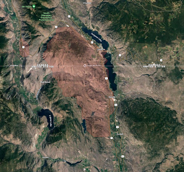
The boundary of the fire is shown here (red colors), placed over a satellite image. The fire started south of the border and then pushed northward.
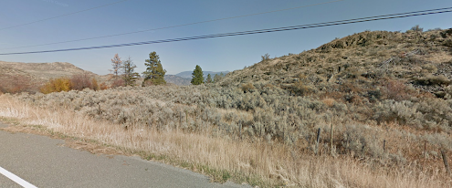
Here is the kind of landscape that burned: grass and range vegetation mainly.
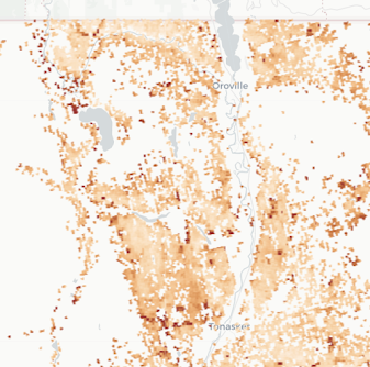
As made clear by the USDA FuelCast analysis, the area had plenty of dead surface fuel (like dried-out cheatgrass) after a wet spring last year....see the FuelCast diagnostic below.
And such grass was dried out and seasoned, as would be expected by mid-summer.
To get a big fire all that was needed was ignition and wind. Well, we can't predict ignition, but unfortunately, there are a lot of irresponsible folks around.
But we can predict the wind. Really well.
The USDA Forest Service has developed a diagnostic called Hot-Dry-Windy, which is wind speed multiplied by a measure of atmospheric drying called Vapor Pressure Deficit (VPD).
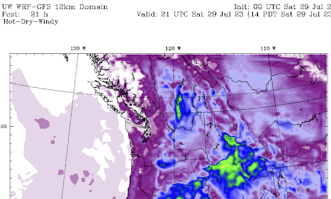
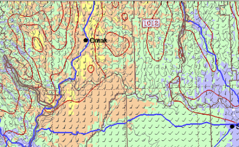
As part of my regional weather prediction modeling work, we predict Hot-Dry-Windy (HDW) out several days. Below is the 21h forecast of HDW valid just when the fire started (around 2 PM on Saturday). Green is a threatening value.
Eureka...just nailed it.
The high-resolution WRF model predicted strong southerly winds at the time of fire blow-up, as shown by the 21-hr wind forecast below (yellow colors indicate winds of 20 knots or more).
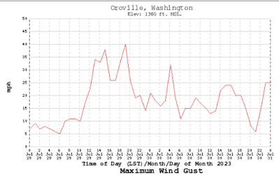
What actually happened? Here are the observed wind gusts at the nearby USDA RAWS observing station near Oroville. The wind surged on July 29th, reaching around 40 mph!
The Eagle Bluff fire is a repeat of the same story I have told before for other fires this year in our area.
- Grass and range vegetation, made worse by invasive cheatgrass over the region.
- A wet spring that encouraged bountiful growth.
- Normal drying (not connected with global warming).
- Strong winds.
- A careless ignition by some individual.
- And an excellent forecast of the winds.
Could we use our excellent weather prediction capability to warn folks more emphatically to be careful?
To get firefighters on scene BEFORE the fire starts?
Finally, one might note that wildfire is not unexpected east of the Cascades--it is a normal aspect of the ecology of the region. We just don't need to help it along so much....




That was a very good forecast and I wish we would have had these forecast tools back during my working days. My only comment about your above list is your comment about "normal drying" this season. It has been worse than normal; a long period of scant rainfall in that area and going on three months of above normal temperatures and below normal humidity. It is true that this fire and the fire down near Bickleton would probably have occurred under "normal" conditions but not with the rapid spread and intense burning experienced by these fires due to the abnormal dryness of this season. Up to now, our fire losses in Eastern Washington may be below normal, but not because the potential is not there as we see from these two fires.
ReplyDeleteonce the light fuels are dry enough to burn, being slightly drier has minimal impact. As you know, these are 1-10hr fuels in any case and rapidly dry out. The potential for big grass fires are there every summer...the question is about ignition and wind.
DeleteThe capacity to forecast fire conditions really is a cool and important development. This was an informative post. Thanks, Cliff.
ReplyDeleteWhile I'm posting, curious to get your thoughts on what appears to be a truly remarkable winter heat wave in South America: https://www.washingtonpost.com/weather/2023/08/02/southamerica-record-winter-heat-argentina-chile/
Cliff, my apologies for going off subject here, but the next time any pinhead from the Seattle Times attempts to write about anything climate related, please point them to this unfortunate soul who was fired only weeks after moving halfway across the country to take a position there:
ReplyDeletehttps://www.thefp.com/p/seattle-times-writer-fired-over-hitler-lenin
If this isn't yet another example of the Orwellian/Marxist tyranny that's been enforced across all of the MSM platforms, I don't know what is.
I think we've had disagreements, primarily about the existence (or at least severity) of anthropogenic climate change, but in this specific instance I'm with you. This journalist should not have been fired.
DeleteI'm not entirely sold that this speaks to broader trends in journalism (other than maybe a certain cowardice when it comes to avoiding controversy?), but this is indeed troubling. Thanks for highlighting this story, even if it's a bit off topic.
SYoung, there's a reason why I chose the name to blog under when I decided to come onto Cliff's site around six years ago. Sadly, the trends I decried back then have only become much more prominent. Regardless of whether people agree or disagree with Cliff's analysis posted here, I believe he's fighting the good fight, and needs all the support he can get right now. Cliff was literally shouted down on a local college campus not too long ago by students who didn't want to hear what he had to say - it was a disgrace.
ReplyDelete