Although unusual, southern California occasionally gets hit by tropical storms moving up from Baja, California, and such an event will occur during the next few days.
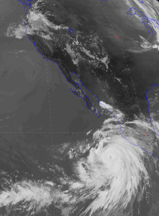
As shown in the satellite image this morning, Hurricane Hilary is now west of Central America and shows a well-defined eye and impressive cloud/rainbands.
The latest forecasts suggest that Hilary will move north-northwest towards southern California and greatly strengthen during the next few days, followed by a rapid weakening.
Below are the forecast tracks of several model prediction systems (left panel), as well as the predictions of the maximum wind speeds and central pressure (right panels) that I accessed from the NOAA/NWS HWRF website.


The latest European Center model forecast rapidly weakens the storm as it moves northward up Baja, California, ending just south of San Diego at 6 PM PDT Sunday.

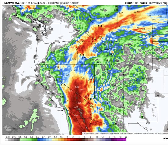
But although weakening, Hilary will bring a large amount of rain to the western U.S. Below is the European Center total precipitation prediction through 11 AM Wednesday.
Wow. 2-6 inches over southern California and a deluge over southern Nevada.
Eastern Oregon gets a piece of it, as does Idaho and western Montana.
We are now about to enter a cool-off period for the Northwest and I suspect that Puget Sound will not see another 90F day until next summer.
This has been a very benign wildfire year for Washington State, something shown by the latest wildfire statistics provided by Washington DNR.


No comment about the upcoming smoke entering the westside this weekend? What will the impacts be?
ReplyDeleteOne of the oddities of fire reporting is the "acres burned". While burning is active a perimeter is generated on a map and reported in the news.
ReplyDeleteLater the land manager, say the US Forest service, may use ground surveys and imagery to assess actual burned acres classified into levels of severity. Such reports can come out 2 years after the fire, and most everyone has moved on.
Severely burned areas may get some help with re-vegetation. I helped plant sagebrush plugs on such a burn SW of Ellensburg, WA [Evans Canyon Fire]. Others spread many pounds of locally sourced native grasses.
Next time need sagebrush give me a buzz. Would love to donate some of our old growth. We were only spot left from origin of cold springs fire in Okanogan to the Columbia River that had sage brush. I was out on other spots of fire and by time got back to my house wind had shifted and was premium for back burn. Then I look down the way and the were already hardlining with a dozer. Would of loved to burn it off.
DeleteWhat was the seed mix of these native grasses? Surely the mix didn't include cheatgrass?
DeleteThank you, cold-water Pacific Coast! However, we sure do miss substantial rainfall this year.
ReplyDeleteThat's good and welcome news for eastern OR, wish some of it would reach us. Can you comment on the likelihood of the North Cascades fires' smoke being pushed towards Puget Sound? I usually associate cooldowns with westerly flow/marine push so I'm hoping the doomsayers are wrong: "According to KIRO 7 Pinpoint Meteorologist Nick Allard, winds will likely turn out of the northeast on Saturday and continue through Monday. Those winds will bring smoke from a smattering of wildfires both in Washington and across the border in Canada."
ReplyDelete"doomsayers"? This has nothing to do with climate change or any doom forecasting. Nick Allard is using an accurate forecast. Unhealthy (in most of the area) to Hazardous smoke (up around Bellingham) is very likely to infiltrate the area some time tomorrow and into Sunday due to strong offshore flow. NWS forecasts have it pushing out on Monday due to onshore flow, but I suspect a good amount of it will linger into Wednesday since the onshore winds won't be very strong.
DeleteIf those decent rains make it up to Idaho it could really help with some of the fires in the panhandle. That aside, it's interesting to watch see the forecast storm track for Hilary - reminds me a bit of when I lived in Ohio and we'd occasionally get tropical storm remnants move all the way from the gulf coast.
ReplyDeleteKOMO Weather says: "Our latest streak of 90-degree heat is nearing the end. But what's made this spell of heat so concerning has been the uncomfortably warm nights. For the first time in 130 years of recordkeeping, the low temperature failed to fall below 67 degrees in Seattle for three nights straight."
ReplyDeleteSince when is 67 degrees a hot night? Obviously their staff have never been to the East coast, to say nothing of the Caribbean...
DeleteAll the concrete and rooftops retain heat over night in the cities especially Seattle, out where we live in the hills north of Arlington the night time Temperatures have been averaging in the low to mid 50s during this "heat wave." most of July the night Temps were in the mid 40s this Summer
Delete"Since when is 67 degrees a hot night? Obviously their staff have never been to the East coast, to say nothing of the Caribbean..."
DeleteAnd folks from the Caribbean would find our nights uncomfortably cold. "But it's hotter some place else" is an irrelevant argument. What is normal for where you are and what you are accustomed to is what makes a temperature uncomfortable and noteworthy.
Sure, nights are hotter on the east coast, but most homes have A/C there. If you're relying on night air to cool your house that might be 85 degrees inside by early evening, you need cooler evenings than we've had this week (preferably well before you go to bed).
DeleteLooks like we won't get a piece of the rain. Pity, we need it. Unless the coming marine push will generate a convergence zone.
ReplyDeleteI'm hearing a new phase from some overly sensationalist forecasters on TV: "Dry, unstable air". I thought that summer highs are associated with inversions... Can someone tell me what kind of rubbish they are trying to feed us? I always thought that unstable air causes convection, and convection causes clouds and rain, usually with thunder and lightning, unless dewpoints are extremely low- but they deny that any rain is in sight. With our current dewpoints in the upper 50's to 60, if the air were really unstable there would be convective showers, right?
ReplyDeleteIn arid and desert parts of the world it is common to have a dry unstable air mass. There is plenty of convection but literally not enough moisture to form clouds. For example, you will experience this as turbulence if you fly into Las Vagas on a hot day. This would never be the case with dewpoints in the 50s or 60s though.
DeleteWhy is this storm labeled a hurricane and not a cyclone?
ReplyDeleteA hurricane is a type of cyclone, which if I'm not mistaken, broadly speaking, is any storm with a circular flow structure- includes everything from large mid-latitude cyclones to tornadoes.
DeleteI thought the distinction was that hurricanes originate in the Atlantic or Gulf of Mexico while cyclones originate in the Pacific. Maybe Hilary originated in the Gulf and crossed over Mexico to the Pacific.
DeleteWhy is there an air quality alert for the weekend? We've got onshore flow (finally), so it doesn't make sense for the smoke to move SW.
ReplyDeleteYou might want to look up the Haines Index which explains and measures how dry, unstable air can affect forest fires. Acres burned may still be relatively low in Washington but not because the potential for large fires is not there. Humidity levels today, below 10% at several stations in Eastern Washington, are about the lowest I have seen for this time of the year. And very large fires are burning just to the north in British Columbia with some new ones in Eastern Washington. Lets hope some of that moisture moving north from the hurricane reaches our area soon.
ReplyDelete