Every meteorologist knows that climatology only provides typical or average conditions and that natural atmospheric variability can provide some major excursions from normal conditions.
That will certainly be true next week. Climatologically, the last week of July is the driest of the year in western Washington (see plot at SeaTac below). Best time of the year to plan a barbecue or an outdoor wedding.
But this year, the last week of July will bring rain...and even significant rain in some locations.
Let me show you.
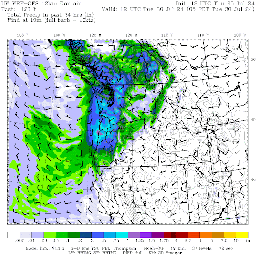
The weekend will be generally dry, with a wet system moving in Sunday night/Monday morning.
The 24-hour totals ending 5 AM Monday show lots of rain along the coast, with moisture extending into NW Washington.
How certain are we of this rain?
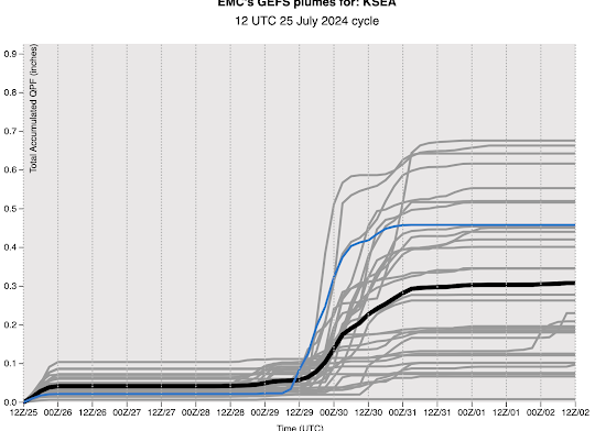
Take a look at an ensemble of many predictions for rain accumulation in Seattle for the next week using the National Weather Service's GFS model. Each gray line is a different forecast with the blue line being the high-resolution prediction. Considerable variation (and thus uncertainty), but nearly all the forecasts predict rain.
And don't forget the temperature. The highly accurate Weather.com website has the high on Monday not even getting into the 70s (see below).
This cool/wet period should have minimal thunderstorm activity and will help reduce subsequent wildfire activity.


It seems pointless to get this rain when it's gonna get hot and dry again right afterwards. why not stay hot and dry thru the end of summer than turn cool/ wet, odd.
ReplyDeleteThe atmosphere is trying to make a point? Have you thought about talking to the atmosphere directly? You never know - the atmosphere might listen to your suggestion.
DeleteTalk to God about that. Let us know what He decides...
DeleteMaybe try a sun dance? Can't hurt....
DeleteCliff, regarding what you said a few days ago about global warming making July drier: It seems like when the ocean warms, it should lead to more evaporation and then, necessarily, more precipitation. In your book you point out that AGW will bring more onshore flow because of more heating of the interior, i.e., east of the Cascades, at least in the spring. Why then would summer be drier, if there is more moisture in the air over the ocean and more onshore flow?
ReplyDeleteThere may come a little dampness for the area near Ellensburg. The Cascades are causing dryness here. We should use some of the Carbon-tax dollars to shave a thousand feet off the crest. That would produce a climate change. Problem solved.
ReplyDeleteFreaky Rain happens!...Back on 26 July 1970, Jimi Hendrix gave his final Seattle concert, at Sick's Stadium. It rained heavily, all afternoon!...Hendrix was bummed out by that...and his road crew did their best to insulate the stage from the wetness. And a year earlier in Seattle, the 23rd of May 1969 saw the temperature hit 90*...a record that stood for many years. Hendrix was playing the Seattle Center Coliseum that night...towards the end of his show, lightning flashed outside the building, and 12,000 patrons got soaked by a freaky storm, heading outside to their cars. Always a throw of the dice, in Seattle!
ReplyDeleteOne thing to watch is the USGS temperature gauge in the Okanogan River. There was a huge return of sockeye salmon to the Columbia this year, with most originating from the Okanagan river in Canada. Most have made it up to Wells dam in the Columbia, but the temperatures of 75f- have prevented them from moving up into the tributary. Once temperatures decline down to 72F, they will be able to tolerate the temperatures and return to their lake. about 80% of years, there is a thermal block like this but a summer storm will bring temperatures down for some brief periods. Sometimes there is a bad year where many don't make it.
ReplyDeleteIf I remember correctly, this set-up seems to happen every few years in midsummer. Lots of natural variability, hot years, cool years, wet years, dry years, and all sorts in between. Keeps it interesting.
ReplyDeleteThe forecast has been indicating that this event will be similar to the midsummer deluge that the Bellingham area received late last July, which was, similarly coincidentally, rainless prior to and following the storm.
ReplyDeleteIt's been very cool past couple of days...so I was perplexed by the headline on Fox13: "Seattle sees second-hottest July ever recorded"...uh, excuse me...July isn't over?
ReplyDelete