The differences in temperature between noon today (Wednesday) and yesterday are quite large west of the Cascade crest (see plot below). Some locations are 15-20F cooler, particularly across southwest Washington and NW Oregon.
The Columbia Basin temperatures were relatively unchanged.
With cooler air moving in across the coastal region, low-level air pressure is increasing there, producing an enhanced difference in pressure across the Cascades.
Such increased pressure differences increase westerly winds (winds from the west), and we can see the wind strengthening over the eastern slopes of the Cascades. For example, the wind at Ellensburg is now gusting above 35 mph (see plot below).
Such increased winds result in increased wind energy generation (see green line below), which is good...we need it.
The next few days should bring steadily declining temperatures over western Washington.
Let me show you the state-of-the-art UW ensemble of many high-resolution forecasts for Seattle temperatures. High around 85F today and 80F tomorrow. Temperatures at night decline to the upper 50s. Decent sleep beckons.
The National Weather Service NBM forecast is similar and very boring. No heat waves. No cold waves. Just perfect weather rising into the lower 80s.
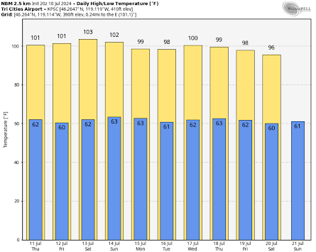
In contrast, the Tri-Cities will remain around 100F for the same period (see below).
No rain is predicted on either side of the Cascades during the next week.
Enjoy the weather.


Thank you for this info. It's really useful for those of us who scratch our heads about how one day's clear, sunny day can be so different from another day's clear, sunny day.
ReplyDeleteAt Ellensburg airport KELN
ReplyDelete5 pm Tues 9th 106° light wind
5 pm Wed 10th 95° 35mph
Cliff, humor us that have endure 100+ and still will for foreseeable future (Okanogan valley). Predictions for winter 24-25, please say it will be COLD and SNOWY!
ReplyDeleteYes, please! I'm ready for fall. This heat, and light from 5am until 9pm, is making me crazy. And cranky. BTW, Cliff, is the first map in your posting the correct one? I see temps in the minus numbers, and zero east of those. Or did i miss something?
DeleteI think it's very likely Seattle will break the record for consecutive 80+ days according to weather.com not a single day under 80.
ReplyDeleteFor Budd: Humor - - move north to Osoyoos and your 100° becomes 37.8; you will feel much better. 😉
ReplyDeleteThanks for that. Need to take drive up there though, been a long time since I've been across the border.
DeleteJohn, we have the Kelvin, the Centigrade, and the Fahrenheit temperature scales. What you advocate for Budd suggests the need for a Retrograde temperature scale.
Delete