______________
Announcement
The Northwest Weather Workshop, the annual gathering to talk about Northwest weather, climate, and major meteorological events, will take place on May 1, 2021. This year we will have a special session on the meteorology of the September 2020 regional wildfires. The meeting will be online. More information, the agenda, and registration information is found here: https://atmos.uw.edu/pnww/
__________________________
The visible satellite imagery yesterday was intriguing, with the development of interesting cloud-free zones, driven by local sea breezes, land-water contrasts, and slope winds.
Let me show you.
At 9:16 AM (1616 UTC) there were lots of low clouds from the Cascade crest westward.
By 11:51 AM, the heating by the strong late-April sun was having an impact, with the development of instability clouds.....cumulus clouds... over land. But not over water, which does not change temperature much during the day. Note the development of clouds over some of the ridges in eastern Washington.
The satellite image at 2:16 PM shows profound clearing in the Straits of Juan de Fuca and Georgia, clearing near Puget Sound, and clearing along the coast. Why?
And the situation at 4:51 PM goes further, with the coastal clear zone over the Strait moving inland, with the clearing extending eastward of Whidbey Island.
It all makes total sense, as I will now explain.
Along the coast, a fairly strong sea breeze developed, with heating over the land causing an in rush of cool, marine air at low levels (see schematic). The low-level cool air cut off the instability that creates the cumulus clouds, which require a large change of temperature with height to form (warm surface, cool atmosphere aloft).
Furthermore, the sinking air behind the sea breeze over water kills off clouds. Notice how clear the coast zone became!
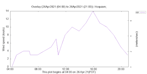
If you want to see proof of the sea breeze, here are yesterday's wind speeds and direction at Hoquiam--located on the central WA coast. Winds increased during the day to 14 knots and switched from easterly (from the east) in the early morning to westerly by noon. Classic sea breeze.
The Strait of Juan de Fuca cleared for two reasons. First, there was an influx of cool air during the day from the west, as a REGIONAL sea breeze developed between the heated western Washington interior and the cooler coast. Cool air suppresses cumulus development as noted above.
But there is more. There is upslope on the terrain surrounding the Strait of Juan de Fuca, which results in sinking air over the Strait (see schematic). And sinking air is bad for clouds.
Clouds cleared over Puget Sound and the Strait of Georgia for similar reasons. And the cloud clearing east of Whidbey Island was associated with cool air pushing eastward through the Strait during the day.
What about the clouds developing on the ridges in eastern Washington (see blow-up below). That is due to heating on the slopes causing upslope flow on both sides of the terrain features, resulting in strong upward motion and clouds near the crest (see schematic)
The bottom line is that many of the details of our local clouds during the warm season can be explained by local wind circulations forced by solar heating at the surface.


Thank you, Cliff, for your unflagging energy, enthusiasm, and curiosity about the world around us. Thank you for inspiring wonder and amazement.
ReplyDeleteSo did the sea breeze cut off major growth of the clouds over land? I noticed a anvil shape much lower than the tropopause yesterday (I suspected inversion, but sea breeze would make sense too!)
ReplyDelete