There is a good name for it: a SuperMonsoon.
In my previous blogs, I talked about the nature of the Southwest (or North American) Monsoon, and how water vapor from the Gulf of Mexico swings around a high-pressure area into the Desert Southwest from June to August.
As a result, the southwest U.S. is usually MUCH wetter than the Pacific Northwest during mid-summer.
The Southwest Monsoon has been particularly active this summer with lots of thunderstorms and an unusual westward and northward penetration of moisture.
Take a look at the percent of normal rainfall during the past month.
Wow. Some areas (Nevada and southwest California) have been hit by over 800% of normal rainfall. Folks needed an umbrella in Las Vegas!
This summer's monsoon has been associated with unusual amounts of water vapor moving northward out of the tropics.
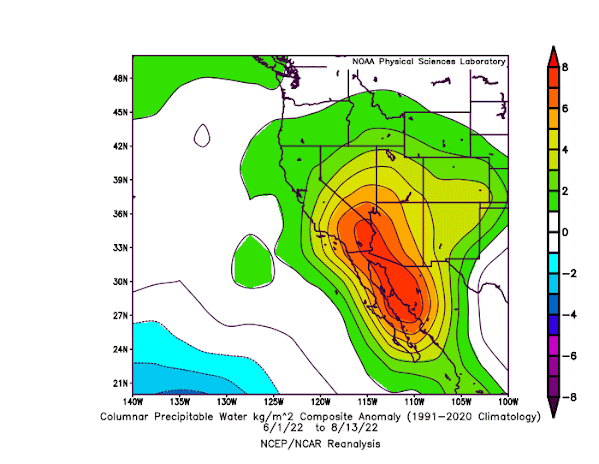
To demonstrate this to you, below is a plot of water vapor anomaly (difference from normal) for June 1 to August 13th. Greens to red are above normal. Wow...lots of oranges and reds....well above normal water vapor amounts heading northwestward out of Mexico into the Desert Southwest! Some of it even reaches the Pacific Northwest.

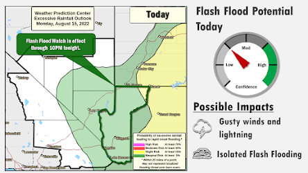
With all the moisture, bringing precipitation and thunderstorms, the Las Vegas National Weather Service have been busy putting out flash flood warnings (see one from yesterday below)

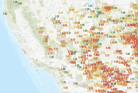
Looking at the total rainfall map since June 1, only showing values above 1.5 inches, lots of areas in the southwest have gotten over 4 inches, with a few locations getting 5-17 inches.
Interesting, last year was also a big Southwest Monsoon year...in fact, even more impressive than this year.
Is there a trend in Southwest Monsoon rainfall? To gain some insight into this question, below is a plot of July Arizona rainfall for over a century.
This year the July rainfall across Arizona is clearly above normal (and the heaviest precipitation was during August), but last year had exceptional July rain. Some really heavy rain about 100 years ago, and July 2020 was very dry. But all and all, a lot of precipitation variability but with little trend.
Some climate model studies suggest that the Southwest Monsoon will get drier and others project little overall change (drier first half, wetter second half of the summer). But considerating that thunderstorms/convection produces most monsoon rainfall and that climate models don't handle them well, I suspect the jury is still out on the topic.
One final thing. Last year's bountiful Southwest Monsoon resulted in heavy grass growth that contributed to the terrible New Mexico fires earlier this year. The Forest Service, BLM, and other wildfire agencies will need to be prepared for an active wildfire season next year.

.png)
.png)


I've been watching Lake Mead level finally start to rise, but I don't see a comparable rise last year. Was last year's summer Monsoon different or was the lake managed differently?
ReplyDeletehttps://mead.uslakes.info/level.asp
The $64,000 question is how does it help reservoir levels in the southwest? The press has been reporting a lot about record low levels at Lake Mead and on other reservoirs. Certainly, rain like this must help, yet there's lots of incomplete and conflicting media reports on this topic. Some call this healthy monsoon season "a drop in the bucket". Checking Colorado river levels, they are up in the last few days (near the Utah/Colorado border) from significantly below the median flow to about or slightly above median flow for this time of year. The flow rates tho are much higher in the spring but were well below normal this spring. So, it appears that heavy monsoons will help a little, but what's really needed is a good or record mountain snow pack in the Colorado River basin. What do the climate models say about that? And are the models any good for that? I hate to see water be such an issue to friends, agriculture etc. in the southwest and hoping for improved water supply.
ReplyDeleteYes this few weeks of higher than normal rain, much of which is out of the lake Powell/mead watersheds will certainly make up for a multi year drought. Problem solved 😆
DeleteI lived many years in Phoenix and for me the monsoons were always exciting. They are such a welcome break from the monotonous heat of summer. I like to watch them develop using the GOES-East Southern Rockies sector Band 11 satellite image viewer. Tonight it looks like something really big is happening in Sonora Mexico near Hermosillo.
ReplyDelete