No, there won't be accumulating snow near sea level, but don't be surprised if you see a few flakes west of the Cascade crest on Friday,
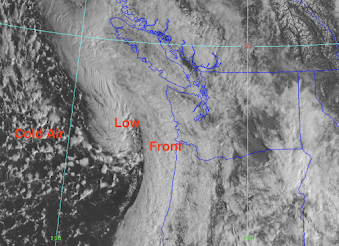
The visible satellite image this morning (below) shows a strong spring-time front about to make landfall on the coast, with a swirl of clouds associated with a low-pressure area evident offshore. To the west, you can see the mottled, white and dark cloud areas associated with great instability, instability caused by cold air passing over warm water. That air is our future.
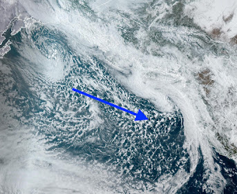
This area of cold air is coming to us all the way from Alaska, as shown by a wider-area satellite image. Call it the Aleutian Express.
The trouble for low-elevation snow lovers is that this maritime air (called a marine polar, MP, air mass) is generally too warm for any lowland snow. But it is the perfect pattern for heavy snow in the Cascades.
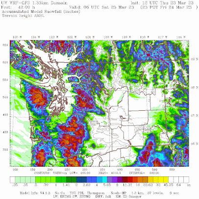
Below is the forecast SNOWFALL total through 11 PM Friday. Some very light snow south of Tacoma, with more over southwest Washington. Not only will the temperatures be marginal, but with the flow off the ocean being northwesterly, Puget Sound will be rain shadowed (or snow-shadowed) by the Olympics.
The Columbia Basin will also be rain shadowed, but the mountains will enjoy as much as a foot of new powder.
On Friday and Saturday, the lowlands will not get above the upper 40s, substantially cooler than normal.
California Madness
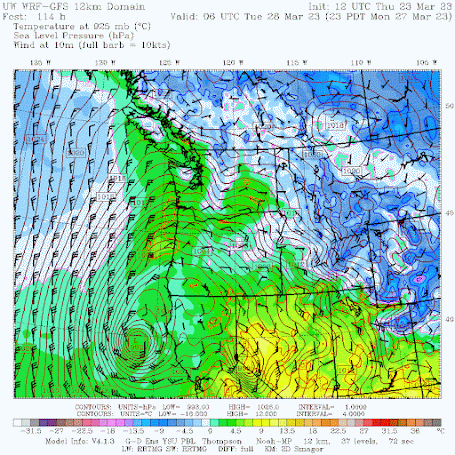
It is hard to believe, but ANOTHER powerful, record-breaking spring storm is being predicted for California. Below is the forecast sea level pressure and surface winds for 11 PM Monday, when a deep, intense low center will approach the coast north of San Francisco.
Will California get heavy precipitation from this system? Do kids like ice cream?
Take a look at the forecast precipitation totals through Wednesday morning. 3-7 inches more precipitation over the Sierra Nevada and northern CA. Perhaps the U.S. Drought Monitor will FINALLY drop severe drought over northern California. Just silly.
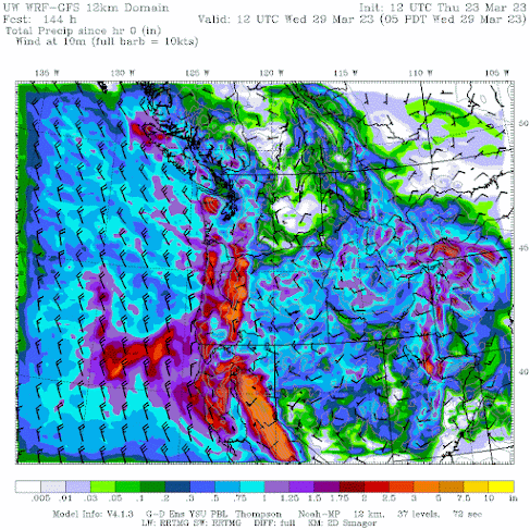


Poor Cali. They either get too much or too little.
ReplyDeleteThe weather plays a cruel zero sum game.
ReplyDeleteI know, imagine having to live in Malibu!
ReplyDeleteI'll give some pushback on your dismissive comment about California drought. While the situation is clearly improving it's reported that 4.6 million people are still facing drought conditions in California. https://www.cnn.com/2023/03/23/us/atmospheric-river-winter-california-drought-climate/index.html
ReplyDeleteCNN is NOT a reliable source of information about weather and climate. Truly abysmal. By any reasonable measure of drought, it is over. Huge snowpack, wet soils, reservoirs in great shape.
Delete3/24 was a remarkably chilly day in Whatcom County. I measured a max temp of just 41.2F at a minute after midnight - the coldest daily max temp so late in the season in my record dating to 10/1/2015. The max temp at BLI of 43F is the second lowest daily max temp for this date on record only to that of the frigid 3/24/55 with a high of 33F. The last time there was a colder daily max temp on any date so late in the season at BLI was 3/28/08 with a high of 39F. It's also been rather rainy. The 1"+ that I've measured over the past couple of days is the most that's fallen in any 2-day period since late December. After temps in the 60s several days ago, the warmest March weather since 2019, we've abruptly transitioned to "Decemarch"!
ReplyDeleteI also just noticed that all of the precip which accumulated at my location on 3/24 fell at a temp <40F - a notably anomalous occurrence for this time of year to be sure.
ReplyDeleteI saw a few half-melted flakes fall in the early afternoon. What a weird "spring" this is
ReplyDeleteUnsurprisingly, 3/24 was also rather dark and gloomy with just 2.9MJ/m^2 of cumulative solar energy at my location compared to 14.3MJ/m^2 on 3/22.
ReplyDelete