The western U.S. is experiencing one of the coldest end-of-winter periods in the historical record, with too many cold records to list.
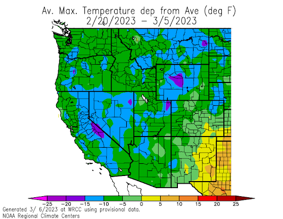
To illustrate, let me "warm up" by considering the departure from normal of the average maximum temperatures across the region (below).
Unbelievable-- in some parts of the region highs have been down by OVER 15F from normal.
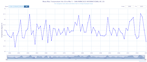
Consider the long-term trend of the average high temperature at Los Angeles for the same period (2/20-3/5)
You will not believe it (below). The last two weeks were the coldest for the entire record, going back to the mid-1930s. LA residents are probably staying in their hot tubs.
For San Francisco, the past two weeks have had the coolest maximum temperatures since the latest 1960s.
Portland? The latest two weeks tied for the second coldest for the entire record.
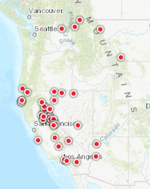
During the past few weeks, a large number of major low-temperature records were broken in the West. Not only were a huge number of daily records broken, but MONTHLY low-temperature records as well. That is very, very unusual.
Below are the locations of monthly temperature records noted during the past several weeks. What has happened in California is extraordinary.
So why such a profoundly cold period?
It is due to high amplitude, and unusual large-scale circulation in the atmosphere.
Below is a map showing the difference from normal for the heights (like pressure) around 18,000 ft (500 hPa pressure).
You will note a HUGE high-pressure anomaly over the northeast Pacific (red/orange) and a strong trough of lower heights/pressure over the west coast (blue colors). This pattern is a very cold one for the West Coast, with northerly flow over the northeast Pacific.
What is the predicted surface temperature anomaly for the next 7 days? You guessed it, colder than normal (see European Center ensemble system prediction below).
Now I can't help noting something.
If this was a record-breaking warm anomaly of the same magnitude, the media would be going crazy talking about climate change and global warming. The Seattle Times cartoonist David Horsey would have gone to town.
What will you hear from them regarding the cold wave and climate? (see below)

.png)

.png)


Maybe warmth by April. Some of us have outside work that isn't getting done.
ReplyDeleteTrimming trees, shrubs, and planting gardens is going to crowd the schedule.
The plus side means that the snowpack continues to grow (and I think harden)
so the irrigation water east of the Cascade Crest will be plentiful.
Thanks Cliff.
Is this analogous to what we get is early summer just around the time "June Gloom" is replaced by a drier flow out of Canada?
ReplyDeleteI thought that this kind of surface cooling event is exactly what should be expected from a warming atmosphere, where additional warmth in the upper layers of the atmosphere is disrupting the usually stable polar vortex.
ReplyDeleteNo...you don't get cooling from a warming atmosphere. Less cold waves as the earth warms....cold waves have declined in the west during the past decades.
DeleteTo add to Cliff's point, here's a recent summation regarding CA from Accuweather, of all places:
ReplyDelete"The stormy pattern this winter hasn't only put a dent in the drought, it will eliminate it by the time spring evolves into summer," AccuWeather Chief On-Air Meteorologist Bernie Rayno said, noting that the drought's reduction has already been significant across the state.
Now let's all bookmark this statement, and then compare it to the other MSM declarations as we head from Spring into the predictable drier months of Summer. Anyone want to take odds that this new reality will NEVER be mentioned again?
The "drought" is all about federal funding.
Deletehttps://www.cbsnews.com/losangeles/news/california-310-million-federal-funding-combat-drought/
I have read that climate change is very much cold snaps as well...the jet stream that typically separates warm areas from polar regions gets weakened allowing the fluctuations to whip like a uncontrolled water hose. An example is the Pacific high pressure, warm, forcing the jet stream into the freaky trough that we see here. We have witnessed huge variations in the path of these jet streams resulting in historic high temps and polar vortexes. It is all climate change related...to suggest otherwise is just disingenuous. .
ReplyDeleteChris...you have the facts reversed. Global warming results in fewer and weaker cold waves. This is supported by both observations and models. There is no indication that global warming has caused more undulations in the jet stream..cliff
DeleteIsn't it expected that global warming would create this kind of effect? More energy in the atmosphere means a less stable atmosphere. Extremes become more common.
ReplyDeleteNo...this is not correct. See my answers above.
DeleteGot some thunderstorms popping up in NE Pierce County. This pattern seems a lot like one we get in the summer that also brings these storms rolling off the Cascade Crest.
ReplyDeleteThe pesky lows spinning off the coast bring in some unusual weather at times. What's next?!?
The noteworthily wintry weather in the western portions of the U.S. (primarily CA) has of course been accompanied by equally or more noteworthy anomalously warm weather in the east with numerous daily and monthly heat records having been set from TX east to FL and north to VA.
ReplyDeleteSo much commentary being posted to be taken out of context while disregard for the big picture is probably in full effect. As far as the whole PLANET, how warm or cold was this winter? Climate Change used to be called "Global Warming" but that was too specific. So, cutting past the ambiguity, what was the average for the whole PLANET, since it's technically summer in the southern hemisphere? If the whole PLANET was warmer than average even AFTER taking a chilly west coast La Nina winter (supposedly normal) into account, what does that mean? Purely rhetorical, of course.
ReplyDeleteFrom Yaleclimateconnections "The Arctic is warming nearly four times faster than the rest of the planet, which tends to cause a slowing of the jet stream winds and increases the jet stream’s tendency to make contorted high-amplitude loops that remain stuck in place for extended periods (see video explainer below from Peter Sinclair). This change leads to more intense and longer-duration heat waves, droughts, flooding events, and cold snaps. " Jeff Masters U of Michigan
ReplyDeleteAnd now there is confirmation using rigorous analysis: Wavier jet streams driven by zonally asymmetric surface thermal forcing. PNAS September 12, 2022
119 (38) e2200890119.
Unfortunately, Yale Connections is a climate advocacy group and the paper you site was a non-peered reviewed publication based on a highly simplified theoretical model. Realistic models (e.g., GCMs) don't show such behavior.
DeleteEvery year we seem to be either too warm or too cold. The pnw is not supposed to be an area of extremes so when is the weather "normal"?
ReplyDeleteYes, I guess the proper question is: Is the standard deviation (for temperature at a specific time of year) increasing, decreasing, or not changing?
ReplyDeleteJust listened to your podcast Cliff. As evidence to support your point about cold waves, I point out that in the last couple decades, the mountain pine beetle, a pest which is, however, native to the Rockies, has gone hog-wild and is killing pines, particularly lodgepole pines, left and right there. It is said that the pine beetle is killed by cold only if/when the temperature drops to -30 degrees F. for several days- and this has gotten rather rare even in the Rockies which used to get down below -40 rather often.
ReplyDeleteOff topic, is there going to be an in-person weather workshop this year?
Yes, on Friday-Saturday, May 12-13
DeleteWe should be skeptical of media characterizations which serve an agenda.
DeleteBeetle infestations rise in warmer periods. What’s unprecedented is the effect of fire suppression and logging practices (eg clearcuts which modify hydrological outcomes) which has created more homogenous, less resilient forests more vulnerable to both fire and pest.
The threshold for significant beetle reproduction impact is about -10c early season or -35c late season but it’s tied to how quickly the temperature changes vs how quickly the pest can produce glycol.
‘The Rockies” is a huge area but most areas easily reached those thresholds this winter with lots of rapid temperature fluctuations. Pine resin production should also be good this spring with all the moisture. Dry periods reduce pine resin production and increase tree vulnerability.
I don’t know about the rest of you but I could sure go for some global warming right about now.
ReplyDelete